
Ötztal Alps · 3,738 m
Weißkugel - Palla Bianca
3 routes to a 3,738 m summit in the Ötztal Alps area, from F (easy).
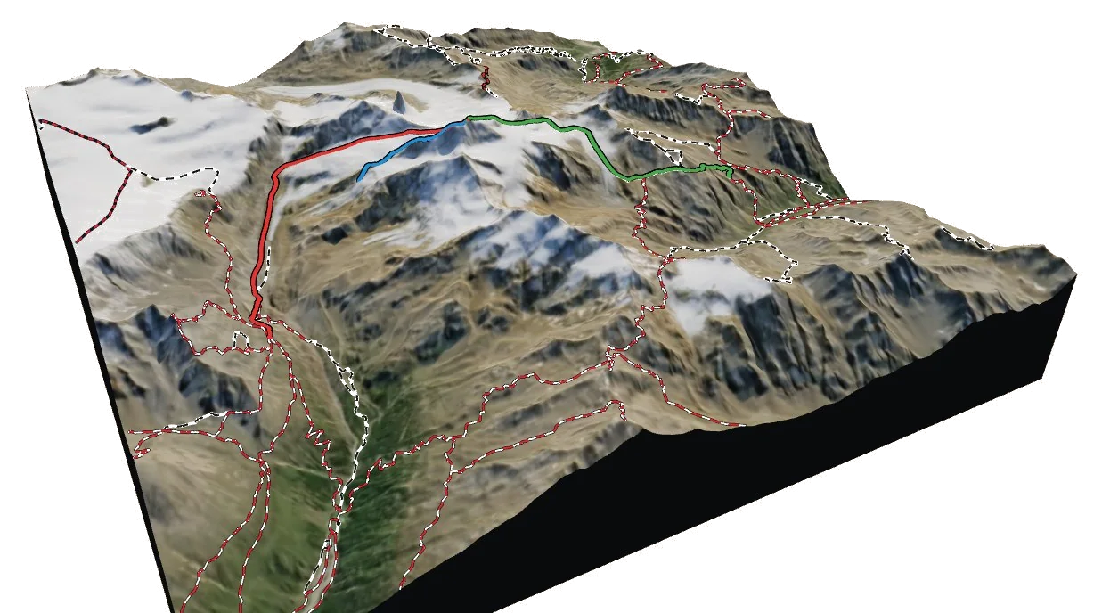
Overview
About Weißkugel - Palla Bianca
Weißkugel - Palla Bianca rises to 3,738 m in the Ötztal Alps area of the Alps, and is also known as Weißkugel and Palla Bianca. The nearest village is Kurzras - Maso Corto at 2,011 m, about 6 km away, which leaves roughly 1,727 m of height between the valley and the top. The easiest way up is the Ost-Nord-Ost Flanke (from Weisskugelhutte), graded F with rock moves up to I. The hardest of the 3 listed routes is the NNE Ridge at PD. Most parties spend a night at Oberetteshütte (2,748 m), 3.4 km from the summit. 2 waymarked hikes start within 5 km, useful for acclimatising first.
Climbing
Routes to the summit
F
Ost-Nord-Ost Flanke (from Weisskugelhutte)
Easy · rock up to I
Estimated
Mapped trail or climbers' path reaching the summit from the NE side, taken from OpenStreetMap.
- Grade
- F · rock I
- Time
- 4–6 h up (estimate)
- Height gain
- 1,228 m
- Starts from
- Weisskugelhutte
On the route
- Starts at Weisskugelhutte
- About 6.0 km and 1228 m of ascent on the line shown
- Glacier travel: Langtauferer Ferner - Vedretta di Vallelunga
- Steepest sustained section about 39° (from the terrain model)
Tips
- Rope up on the glacier and carry crevasse-rescue gear
- Steep ground: crampons and ice axe likely needed early in the season
- Check current conditions with the nearest hut or local guides before you go
F+
S Ridge (from Oberetteshütte)
Easy · rock up to I
Estimated
Mapped trail or climbers' path reaching the summit from the S side, taken from OpenStreetMap.
- Grade
- F+ · rock I
- Time
- 4–5 h up (estimate)
- Height gain
- 1,139 m
- Starts from
- Oberetteshütte
On the route
- Starts at Oberetteshütte
- About 5.2 km and 1139 m of ascent on the line shown
- Glacier travel: Matscher Ferner - Ghiacciaio di Mazia, Hintereisferner
- Passes Hintereisjoch (3470 m)
- Steepest sustained section about 35° (from the terrain model)
Tips
- Rope up on the glacier and carry crevasse-rescue gear
- Steep ground: crampons and ice axe likely needed early in the season
- Check current conditions with the nearest hut or local guides before you go
PD
NNE Ridge
Moderately difficult · rock up to II
Estimated
The NNE ridge of Weißkugel - Palla Bianca, traced from the terrain model to the col or ridge foot. No mapped trail follows it.
- Grade
- PD · rock II
- Time
- 2–3 h up (estimate)
- Height gain
- 627 m
- Starts from
- ridge foot at 3074 m
On the route
- About 1.7 km and 627 m of ascent on the line shown
- Glacier travel: Langtauferer Ferner - Vedretta di Vallelunga
- Steepest sustained section about 39° (from the terrain model)
Tips
- Rope up on the glacier and carry crevasse-rescue gear
- Steep ground: crampons and ice axe likely needed early in the season
- Ridge line traced from the terrain model; check a guidebook for the exact line, cornices and gendarmes
- No marked trail mapped here: route-finding skills required
- Check current conditions with the nearest hut or local guides before you go
Alpine grades: F easy · PD moderately difficult · AD fairly difficult · D difficult · TD very difficult. Roman numerals give the hardest rock moves.
The 3D atlas
Don’t just read about Weißkugel - Palla Bianca. Fly around it.
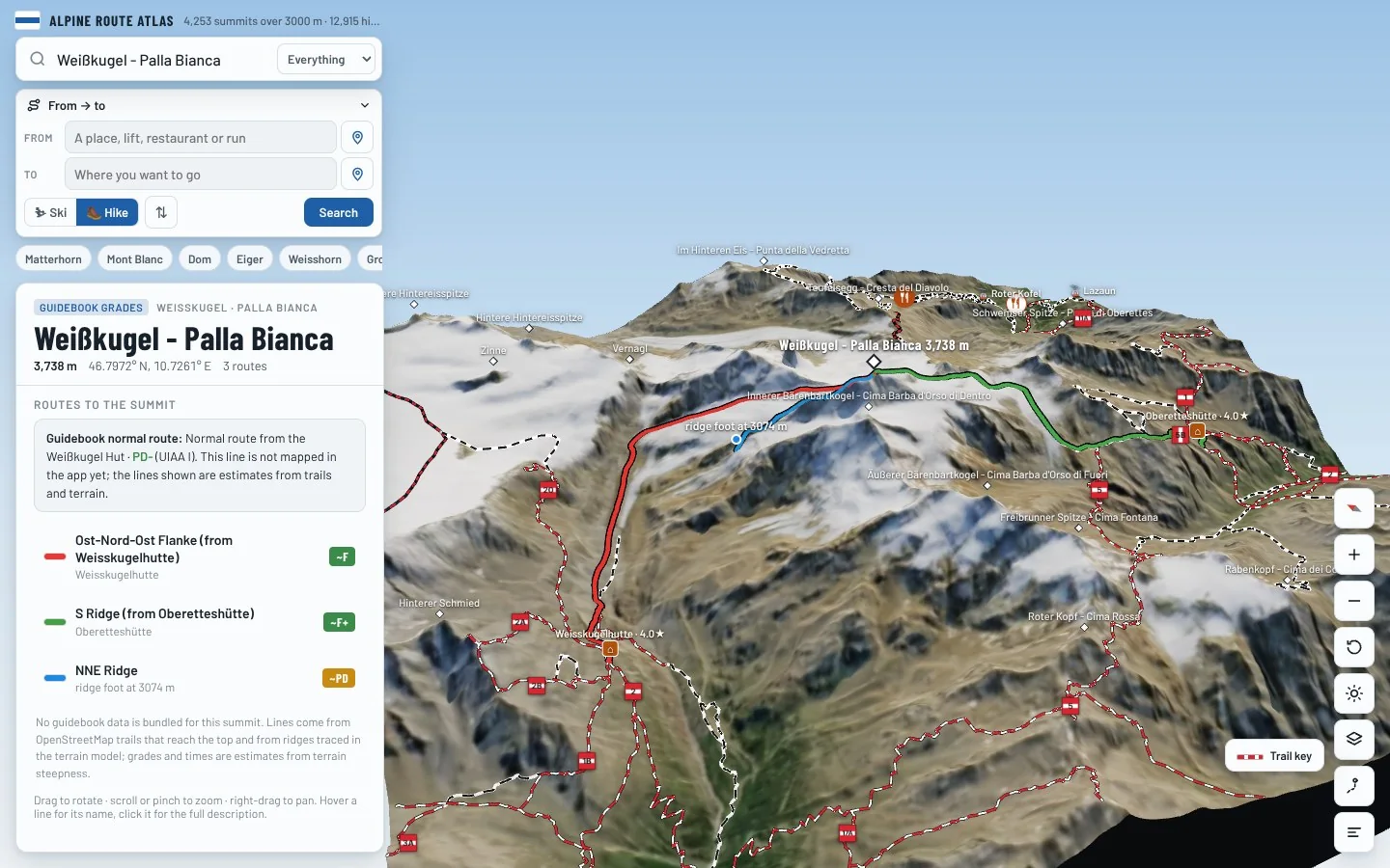
Every route on this page is traced on the real terrain in Berg Explorer. Spin the mountain, follow a ridge to the top and see which huts and lifts get you there.
- Turn and tilt every face in real 3D terrain
- Each route traced in colour, with its grade
- Huts, lifts and waymarked trails on the map
- Free, in your browser, no download
Where to stay
Huts for Weißkugel - Palla Bianca
Nearby
Summits close by
Innerer Bärenbartkogel - Cima Barba d'Orso di Dentro
3,557 m · 0.5 km
Innere Quellspitze - Cima della Sorgente di Dentro
3,514 m · 1.0 km
Langtauferer Spitze - Punta Vallelunga
3,528 m · 1.7 km
Äußerer Bärenbartkogel - Cima Barba d'Orso di Fuori
3,473 m · 2.0 km
See Weißkugel - Palla Bianca in three dimensions
Open the 3D atlas