
Zermatt and Saas · 4,478 m
Matterhorn
5 routes to a 4,478 m summit in the Zermatt and Saas area, from AD+ (fairly difficult).
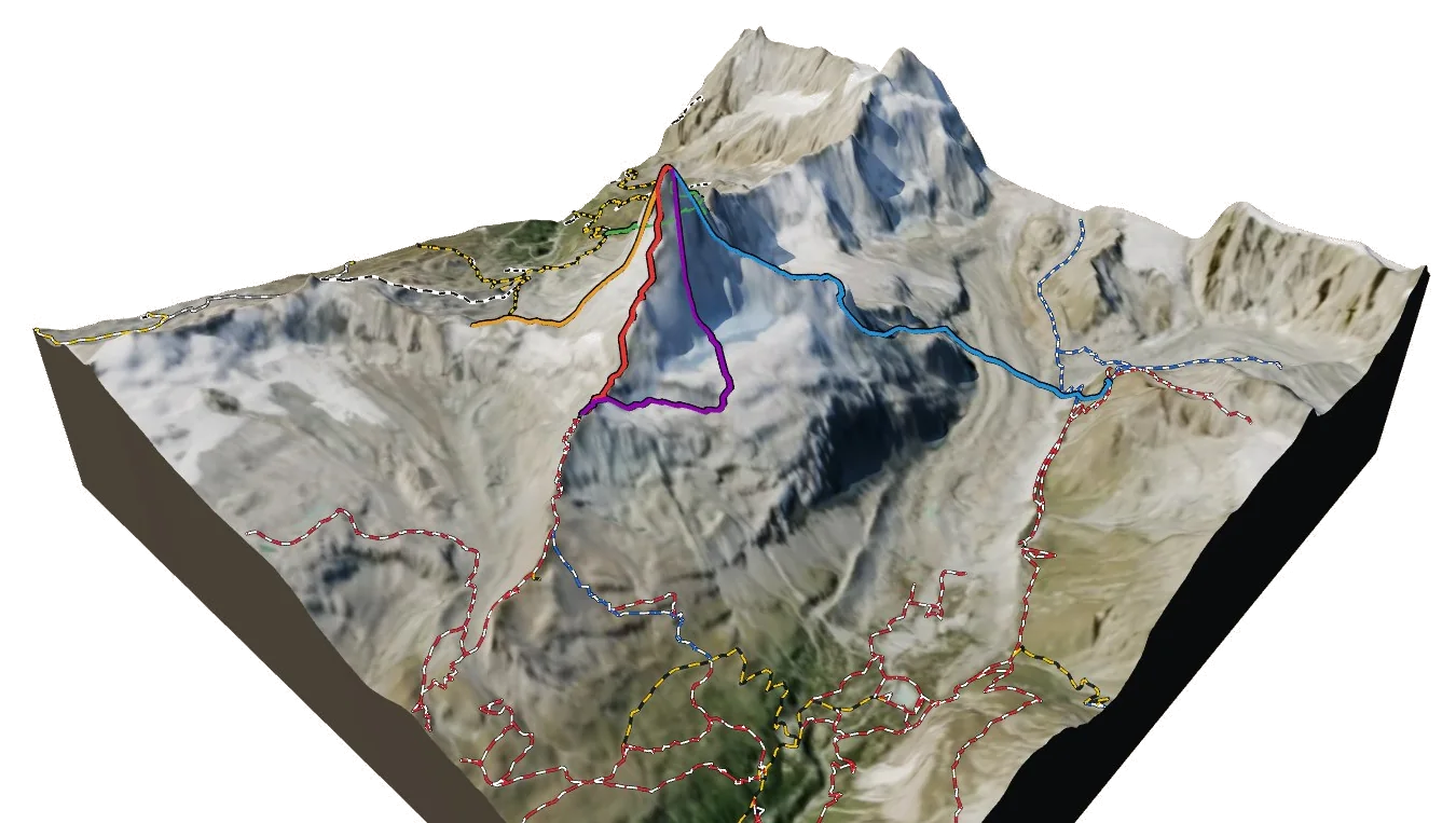
Overview
About Matterhorn
Matterhorn rises to 4,478 m in the Zermatt and Saas area of the Alps, and is also known as Cervino, Mont Cervin and Materhorno. It is one of only 120 summits in the atlas above 4,000 m, and number 17 by height. The nearest village is Breuil-Cervinia at 2,009 m, about 5 km away, which leaves roughly 2,469 m of height between the valley and the top. The easiest way up is the Hörnli Ridge (NE Ridge), graded AD+ with rock moves up to III. The hardest of the 5 listed routes is the North Face (Schmid Route) at TD+. All of them come from guidebooks. Most parties spend a night at Hörnlihütte (3,260 m), 1.7 km from the summit. 2 waymarked hikes start within 5 km, useful for acclimatising first.
Climbing
Routes to the summit
AD+
Hörnli Ridge (NE Ridge)
Fairly difficult · rock up to III
Guidebook
The Swiss normal route and the most climbed line on the mountain. A long, mostly scrambling ridge with fixed ropes on the upper section.
- Grade
- AD+ · rock III
- Time
- 8–10 h return from the Hörnli hut
- Height gain
- 1,220 m
- Starts from
- Hörnlihütte (3260 m), reached from Schwarzsee
On the route
- Moseley Slab, the first steep step above the hut, climbed in the dark
- Solvay emergency bivouac at 4003 m, for emergencies only
- Fixed ropes from the Shoulder to the summit snowfield
- Narrow, exposed snow ridge to the Swiss summit (4478 m)
Tips
- Route-finding low on the ridge is the main difficulty: hiring a local guide is the norm
- Aim to reach the Solvay hut in under 2.5 h; if you can't, turn around
- Most accidents happen on descent, so keep enough energy for it
- Rockfall from parties above is common in the gullies; wear a helmet
- Avoid after fresh snow; the ridge needs to be dry
D-
Lion Ridge (SW Ridge, Italian route)
Difficult · rock up to III+ (fixed ropes)
Guidebook
The Italian normal route, first climbed by Carrel in 1865. Steeper and more sustained than the Hörnli, with many fixed ropes and the famous Jordan rope ladder.
- Grade
- D- · rock III+ (fixed ropes)
- Time
- 2 days via the Carrel hut
- Height gain
- 1,680 m
- Starts from
- Rifugio Duca degli Abruzzi (2802 m) above Breuil-Cervinia
On the route
- Col du Lion (3579 m) and the airy Tête du Lion traverse
- Grande Corde fixed rope below the Carrel hut
- Rifugio Carrel (3830 m) on the ridge
- Pic Tyndall (4241 m) and the exposed Enjambée gap
- Échelle Jordan rope ladder just below the Italian summit
Tips
- The Carrel hut is small and unguarded; carry a stove and food
- Snow often lingers on the ridge to Pic Tyndall, so crampons are needed
- Quieter than the Hörnli but just as serious
- Check fixed-rope condition before relying on them
D
Zmutt Ridge (NW Ridge)
Difficult · rock up to IV-
Guidebook
The most beautiful of the ridges and the least crowded. Mixed climbing on snow and loose rock, finishing on the Italian side.
- Grade
- D · rock IV-
- Time
- 10–12 h from the Hörnli or Schönbiel hut
- Height gain
- 1,300 m
- Starts from
- Schönbielhütte (2694 m) or Hörnlihütte
On the route
- Approach across the Zmutt glacier to the foot of the ridge
- Snow arête leading to the Zmutt Teeth (Zmuttzähne)
- Carrel's Gallery traverse onto the Tiefmatten face
- Joins the Italian summit ridge
Tips
- Needs firm snow on the lower arête; go early in the season
- Rockfall exposure on the Tiefmatten traverse
- Descend by the Hörnli Ridge
- Few parties: you will be route-finding alone
D+
Furggen Ridge (SE Ridge)
Difficult · rock up to IV+ (direct finish V+/A0)
Guidebook
The hardest of the four ridges and the last to be climbed (1911). Loose rock low down and a steep overhanging prow near the top.
- Grade
- D+ · rock IV+ (direct finish V+/A0)
- Time
- 10–14 h
- Height gain
- 1,210 m
- Starts from
- Furggjoch (3271 m), from the Hörnli hut or Plateau Rosa
On the route
- Long, loose lower ridge above the Furggjoch
- The 'Furggen nose' overhangs below the Furggen shoulder
- Most parties bypass the nose by traversing onto the Italian side
Tips
- Rock quality is poor, so choose cold conditions
- Carry enough rack for the upper overhang if going direct
- Rarely climbed: expect no tracks and no fixed gear
TD+
North Face (Schmid Route)
Very difficult · rock up to V, ice 55–60°
Guidebook
One of the six great north faces of the Alps, first climbed by the Schmid brothers in 1931. Ice fields low down give way to loose mixed ground above.
- Grade
- TD+ · rock V, ice 55–60°
- Time
- 12–18 h from the Hörnli hut
- Height gain
- 1,100 m
- Starts from
- Hörnlihütte, crossing the Matterhorn glacier
On the route
- Bergschrund at about 3300 m
- Long ice field in the lower half
- Mixed ground with poor rock in the upper face
- Exits onto the Hörnli Ridge near the summit
Tips
- Best in autumn or winter when the face is frozen
- Little protection on the upper face; climb fast and light
- Line shown is approximate
Alpine grades: F easy · PD moderately difficult · AD fairly difficult · D difficult · TD very difficult. Roman numerals give the hardest rock moves.
The 3D atlas
Don’t just read about Matterhorn. Fly around it.
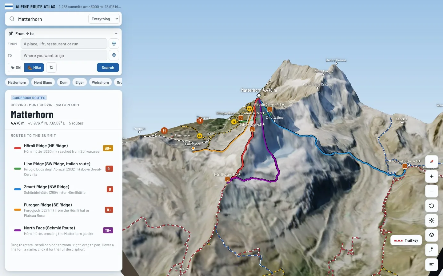
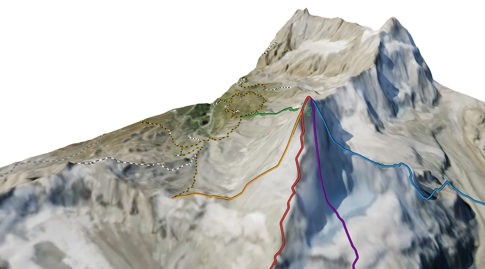
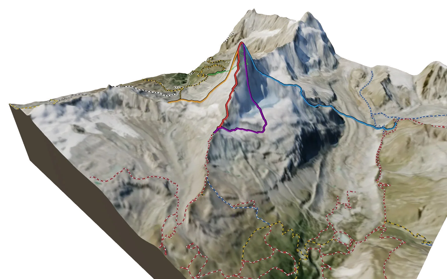
Every route on this page is traced on the real terrain in Berg Explorer. Spin the mountain, follow a ridge to the top and see which huts and lifts get you there.
- Turn and tilt every face in real 3D terrain
- Each route traced in colour, with its grade
- Huts, lifts and waymarked trails on the map
- Free, in your browser, no download
Where to stay
Huts for Matterhorn
Nearby
Summits close by
Zmuttzähne
3,894 m · 0.4 km
Testa del Leone
3,715 m · 1.3 km
Punta Maria Cristina
3,704 m · 2.9 km
Furggen
3,492 m · 3.0 km
See Matterhorn in three dimensions
Open the 3D atlas