
Lepontine Alps (Ticino) · 805 km · 53 days
Via Alpina Blue
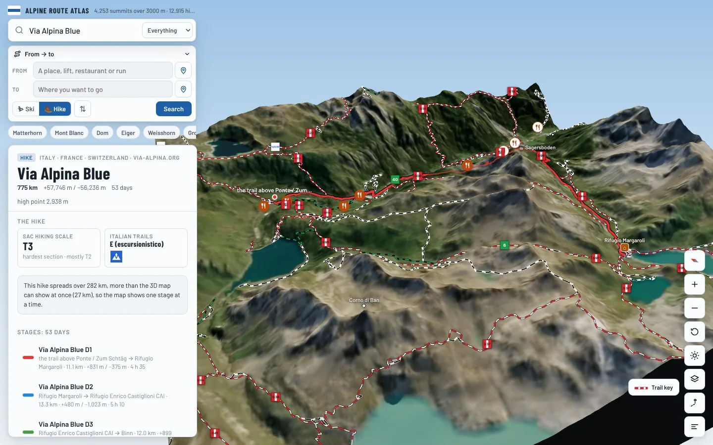
A 53-day trek of 805 km in the Lepontine Alps (Ticino) area, with 60,627 m of climbing.
Overview
About Via Alpina Blue
Via Alpina Blue is an international long-distance trail in the Lepontine Alps (Ticino) area, crossing Italy, France and Switzerland. It runs 805.2 km from the trail above Ponte / Zum Schtäg to the trail near Moulinet. Along the way you climb 60,627 m and descend 59,508 m, between 365 m and a high point of 2,942 m. At a steady pace it takes about 417 h of walking, usually split over 53 days. The hardest section is graded T3 on the Swiss hiking scale, demanding mountain hiking: a demanding path with steep, exposed sections and sometimes hands needed for balance; sure-footedness required. Most of it is easier, around T2. It is waymarked and looked after by via-alpina.org. 12 mountain huts are right on the route, so there are places to eat and sleep on the way. It passes over Mäderhorn, Monte Clopacà and Testa del Carolei.
On the trail
53 stages
Medium
Via Alpina Blue D1
the trail above Ponte / Zum Schtäg → Rifugio Margaroli
11 km · 4 h 35
From the trail above Ponte / Zum Schtäg to Rifugio Margaroli. The day ends at Rifugio Margaroli, a mountain hut: book ahead in summer.
- Distance
- 11.1 km
- Ascent
- +831 m
- Descent
- −375 m
- Walking time
- 4 h 35
- Highest point
- 2,186 m
- Lowest point
- 1,415 m
Medium
Via Alpina Blue D2
Rifugio Margaroli → Rifugio Enrico Castiglioni CAI
13 km · 5 h 10
From Rifugio Margaroli to Rifugio Enrico Castiglioni CAI. The day ends at Rifugio Enrico Castiglioni CAI, a mountain hut: book ahead in summer.
- Distance
- 13.3 km
- Ascent
- +480 m
- Descent
- −1,023 m
- Walking time
- 5 h 10
- Highest point
- 2,597 m
- Lowest point
- 1,642 m
Medium
Via Alpina Blue D3
Rifugio Enrico Castiglioni CAI → Binn
12 km · 6 h 20
From Rifugio Enrico Castiglioni CAI to Binn.
- Distance
- 12.0 km
- Ascent
- +899 m
- Descent
- −1,066 m
- Walking time
- 6 h 20
- Highest point
- 2,479 m
- Lowest point
- 1,462 m
Hard
Via Alpina Blue D4
Binn → Rosswald
16 km · 7 h 30
From Binn to Rosswald.
- Distance
- 16.3 km
- Ascent
- +1,254 m
- Descent
- −824 m
- Walking time
- 7 h 30
- Highest point
- 2,562 m
- Lowest point
- 1,321 m
Hard
Via Alpina Blue D5
Rosswald → the trail above Simplon Dorf
25 km · 12 h 35
From Rosswald to the trail above Simplon Dorf.
- Distance
- 25.2 km
- Ascent
- +1,920 m
- Descent
- −1,769 m
- Walking time
- 12 h 35
- Highest point
- 2,886 m
- Lowest point
- 1,870 m
Medium
Via Alpina Blue D6
the trail above Simplon Dorf → Zwischbergen
16 km · 6 h 40
From the trail above Simplon Dorf to Zwischbergen.
- Distance
- 16.5 km
- Ascent
- +664 m
- Descent
- −1,363 m
- Walking time
- 6 h 40
- Highest point
- 2,001 m
- Lowest point
- 1,227 m
Hard
Via Alpina Blue D7
Zwischbergen → Rifugio Alpe Laghetto
15 km · 7 h 20
From Zwischbergen to Rifugio Alpe Laghetto. The day ends at Rifugio Alpe Laghetto, a mountain hut: book ahead in summer.
- Distance
- 14.7 km
- Ascent
- +1,407 m
- Descent
- −662 m
- Walking time
- 7 h 20
- Highest point
- 2,099 m
- Lowest point
- 1,296 m
Medium
Via Alpina Blue D9
Rifugio Alpe Laghetto → Rifugio Andolla
10 km · 5 h 05
From Rifugio Alpe Laghetto to Rifugio Andolla. The day ends at Rifugio Andolla, a mountain hut: book ahead in summer.
- Distance
- 10.4 km
- Ascent
- +1,238 m
- Descent
- −101 m
- Walking time
- 5 h 05
- Highest point
- 2,047 m
- Lowest point
- 910 m
Hard
Via Alpina Blue D10
Rifugio Andolla → Calasca
17 km · 8 h 10
From Rifugio Andolla to Calasca.
- Distance
- 17.2 km
- Ascent
- +1,063 m
- Descent
- −1,504 m
- Walking time
- 8 h 10
- Highest point
- 1,571 m
- Lowest point
- 465 m
Hard
Via Alpina Blue D11
Calasca → the trail above Piana di Forno
16 km · 9 h 45
From Calasca to the trail above Piana di Forno.
- Distance
- 15.9 km
- Ascent
- +1,938 m
- Descent
- −1,059 m
- Walking time
- 9 h 45
- Highest point
- 2,029 m
- Lowest point
- 453 m
Medium
Via Alpina Blue D15
the trail above Piana di Forno → Riva Valdobbia / Riifu
10 km · 4 h
From the trail above Piana di Forno to Riva Valdobbia / Riifu.
- Distance
- 9.6 km
- Ascent
- +162 m
- Descent
- −1,192 m
- Walking time
- 4 h
- Highest point
- 2,257 m
- Lowest point
- 1,108 m
Hard
Via Alpina Blue D17
Riva Valdobbia / Riifu → Piedicavallo
21 km · 9 h 20
From Riva Valdobbia / Riifu to Piedicavallo.
- Distance
- 21.0 km
- Ascent
- +1,228 m
- Descent
- −1,542 m
- Walking time
- 9 h 20
- Highest point
- 2,389 m
- Lowest point
- 1,064 m
Hard
Via Alpina Blue D18
Piedicavallo → Issime
16 km · 7 h 45
From Piedicavallo to Issime.
- Distance
- 15.5 km
- Ascent
- +1,158 m
- Descent
- −1,262 m
- Walking time
- 7 h 45
- Highest point
- 2,184 m
- Lowest point
- 958 m
Hard
Via Alpina Blue D19
Issime → Nabian
16 km · 9 h 10
From Issime to Nabian.
- Distance
- 15.9 km
- Ascent
- +1,369 m
- Descent
- −1,607 m
- Walking time
- 9 h 10
- Highest point
- 2,334 m
- Lowest point
- 749 m
Medium
Via Alpina Blue D20
Nabian → the trail above Champdepraz
12 km · 6 h 05
From Nabian to the trail above Champdepraz.
- Distance
- 11.8 km
- Ascent
- +1,146 m
- Descent
- −653 m
- Walking time
- 6 h 05
- Highest point
- 1,311 m
- Lowest point
- 368 m
Hard
Via Alpina Blue D21
the trail above Champdepraz → Rifugio Dondena
15 km · 7 h 45
From the trail above Champdepraz to Rifugio Dondena. The day ends at Rifugio Dondena, a mountain hut: book ahead in summer.
- Distance
- 15.2 km
- Ascent
- +1,523 m
- Descent
- −630 m
- Walking time
- 7 h 45
- Highest point
- 2,401 m
- Lowest point
- 1,290 m
Medium
Via Alpina Blue D22
Rifugio Dondena → the trail above Campiglia Soana
7 km · 3 h 35
From Rifugio Dondena to the trail above Campiglia Soana.
- Distance
- 7.4 km
- Ascent
- +638 m
- Descent
- −294 m
- Walking time
- 3 h 35
- Highest point
- 2,820 m
- Lowest point
- 2,185 m
Medium
Via Alpina Blue D23
the trail above Campiglia Soana → the trail above Campiglia Soana
10 km · 5 h 05
From the trail above Campiglia Soana to the trail above Campiglia Soana.
- Distance
- 9.8 km
- Ascent
- +548 m
- Descent
- −1,060 m
- Walking time
- 5 h 05
- Highest point
- 2,909 m
- Lowest point
- 2,016 m
Medium
Via Alpina Blue D24
the trail above Campiglia Soana → Ronco Canavese
11 km · 6 h 05
From the trail above Campiglia Soana to Ronco Canavese.
- Distance
- 10.7 km
- Ascent
- +543 m
- Descent
- −1,609 m
- Walking time
- 6 h 05
- Highest point
- 2,032 m
- Lowest point
- 950 m
Medium
Via Alpina Blue D25
Ronco Canavese → the trail near Ribordone
12 km · 6 h 55
From Ronco Canavese to the trail near Ribordone.
- Distance
- 11.9 km
- Ascent
- +1,218 m
- Descent
- −932 m
- Walking time
- 6 h 55
- Highest point
- 2,086 m
- Lowest point
- 884 m
Hard
Via Alpina Blue D26
the trail near Ribordone → Rosone
13 km · 8 h 55
From the trail near Ribordone to Rosone.
- Distance
- 13.0 km
- Ascent
- +1,384 m
- Descent
- −1,566 m
- Walking time
- 8 h 55
- Highest point
- 2,184 m
- Lowest point
- 1,044 m
Medium
Via Alpina Blue D27
Rosone → Noasca
12 km · 5 h 20
From Rosone to Noasca.
- Distance
- 11.6 km
- Ascent
- +851 m
- Descent
- −733 m
- Walking time
- 5 h 20
- Highest point
- 1,522 m
- Lowest point
- 896 m
Medium
Via Alpina Blue D28
Noasca → Prese-Montone
10 km · 5 h 20
From Noasca to Prese-Montone.
- Distance
- 10.3 km
- Ascent
- +1,009 m
- Descent
- −567 m
- Walking time
- 5 h 20
- Highest point
- 2,008 m
- Lowest point
- 1,062 m
Hard
Via Alpina Blue D29
Prese-Montone → Pialpetta
13 km · 8 h 10
From Prese-Montone to Pialpetta.
- Distance
- 13.1 km
- Ascent
- +1,133 m
- Descent
- −1,561 m
- Walking time
- 8 h 10
- Highest point
- 2,631 m
- Lowest point
- 1,071 m
Hard
Via Alpina Blue D30
Pialpetta → Balme
15 km · 8 h 45
From Pialpetta to Balme.
- Distance
- 15.1 km
- Ascent
- +1,535 m
- Descent
- −1,161 m
- Walking time
- 8 h 45
- Highest point
- 2,471 m
- Lowest point
- 1,040 m
Hard
Via Alpina Blue D31
Balme → Usseglio
13 km · 8 h
From Balme to Usseglio.
- Distance
- 12.8 km
- Ascent
- +1,214 m
- Descent
- −1,400 m
- Walking time
- 8 h
- Highest point
- 2,440 m
- Lowest point
- 1,259 m
Hard
Via Alpina Blue D32
Usseglio → Rifugio La Riposa
28 km · 10 h 55
From Usseglio to Rifugio La Riposa. The day ends at Rifugio La Riposa, a mountain hut: book ahead in summer.
- Distance
- 27.9 km
- Ascent
- +1,868 m
- Descent
- −959 m
- Walking time
- 10 h 55
- Highest point
- 2,543 m
- Lowest point
- 1,262 m
Hard
Via Alpina Blue D33
Rifugio La Riposa → the trail above Novalesa
12 km · 8 h 40
From Rifugio La Riposa to the trail above Novalesa.
- Distance
- 12.2 km
- Ascent
- +1,545 m
- Descent
- −1,148 m
- Walking time
- 8 h 40
- Highest point
- 2,827 m
- Lowest point
- 1,743 m
Medium
Via Alpina Blue D34
the trail above Novalesa → Refuge du Petit Mont Cenis
20 km · 6 h 30
From the trail above Novalesa to Refuge du Petit Mont Cenis. The day ends at Refuge du Petit Mont Cenis, a mountain hut: book ahead in summer.
- Distance
- 19.8 km
- Ascent
- +522 m
- Descent
- −989 m
- Walking time
- 6 h 30
- Highest point
- 2,599 m
- Lowest point
- 1,872 m
Medium
Via Alpina Blue D35
Refuge du Petit Mont Cenis → Bivacco Transfrontaliero Col Clapier Bivouac Hannibal
14 km · 6 h 20
From Refuge du Petit Mont Cenis to Bivacco Transfrontaliero Col Clapier Bivouac Hannibal. The day ends at Bivacco Transfrontaliero Col Clapier Bivouac Hannibal, a mountain hut: book ahead in summer.
- Distance
- 13.9 km
- Ascent
- +999 m
- Descent
- −714 m
- Walking time
- 6 h 20
- Highest point
- 2,749 m
- Lowest point
- 2,123 m
Hard
Via Alpina Blue D36
Bivacco Transfrontaliero Col Clapier Bivouac Hannibal → Rifugio Levi Molinari
21 km · 11 h 50
From Bivacco Transfrontaliero Col Clapier Bivouac Hannibal to Rifugio Levi Molinari. The day ends at Rifugio Levi Molinari, a mountain hut: book ahead in summer.
- Distance
- 20.9 km
- Ascent
- +1,448 m
- Descent
- −2,336 m
- Walking time
- 11 h 50
- Highest point
- 2,742 m
- Lowest point
- 1,828 m
Hard
Via Alpina Blue D37
Rifugio Levi Molinari → Rifugio Arlaud
14 km · 8 h 20
From Rifugio Levi Molinari to Rifugio Arlaud. The day ends at Rifugio Arlaud, a mountain hut: book ahead in summer.
- Distance
- 13.9 km
- Ascent
- +1,305 m
- Descent
- −1,395 m
- Walking time
- 8 h 20
- Highest point
- 2,342 m
- Lowest point
- 1,010 m
Hard
Via Alpina Blue D39
Rifugio Arlaud → the trail near Pelhoun
19 km · 9 h 15
From Rifugio Arlaud to the trail near Pelhoun.
- Distance
- 19.1 km
- Ascent
- +1,360 m
- Descent
- −1,399 m
- Walking time
- 9 h 15
- Highest point
- 2,697 m
- Lowest point
- 1,358 m
Medium
Via Alpina Blue D40
the trail near Pelhoun → the trail near Rodoretto / Rooudouret
17 km · 6 h 40
From the trail near Pelhoun to the trail near Rodoretto / Rooudouret.
- Distance
- 16.9 km
- Ascent
- +972 m
- Descent
- −902 m
- Walking time
- 6 h 40
- Highest point
- 1,707 m
- Lowest point
- 1,122 m
Medium
Via Alpina Blue D41
the trail near Rodoretto / Rooudouret → Rifugio Lago Verde
10 km · 5 h 10
From the trail near Rodoretto / Rooudouret to Rifugio Lago Verde. The day ends at Rifugio Lago Verde, a mountain hut: book ahead in summer.
- Distance
- 10.4 km
- Ascent
- +1,225 m
- Descent
- −88 m
- Walking time
- 5 h 10
- Highest point
- 2,589 m
- Lowest point
- 1,452 m
Medium
Via Alpina Blue D42
Rifugio Lago Verde → Le Roux
9 km · 3 h 55
From Rifugio Lago Verde to Le Roux.
- Distance
- 9.2 km
- Ascent
- +231 m
- Descent
- −1,049 m
- Walking time
- 3 h 55
- Highest point
- 2,646 m
- Lowest point
- 1,772 m
Medium
Via Alpina Blue D43
Le Roux → Rifugio Willy Jervis
12 km · 5 h 45
From Le Roux to Rifugio Willy Jervis. The day ends at Rifugio Willy Jervis, a mountain hut: book ahead in summer.
- Distance
- 12.0 km
- Ascent
- +833 m
- Descent
- −839 m
- Walking time
- 5 h 45
- Highest point
- 2,528 m
- Lowest point
- 1,725 m
Medium
Via Alpina Blue D44
Rifugio Willy Jervis → Rifugio Barbara Lowrie
12 km · 6 h 35
From Rifugio Willy Jervis to Rifugio Barbara Lowrie. The day ends at Rifugio Barbara Lowrie, a mountain hut: book ahead in summer.
- Distance
- 12.4 km
- Ascent
- +999 m
- Descent
- −975 m
- Walking time
- 6 h 35
- Highest point
- 2,678 m
- Lowest point
- 1,708 m
Hard
Via Alpina Blue D45
Rifugio Barbara Lowrie → the trail above Crissolo
17 km · 10 h
From Rifugio Barbara Lowrie to the trail above Crissolo.
- Distance
- 16.8 km
- Ascent
- +1,837 m
- Descent
- −1,119 m
- Walking time
- 10 h
- Highest point
- 2,527 m
- Lowest point
- 1,736 m
Medium
Via Alpina Blue D46
the trail above Crissolo → Rifugio Viso
8 km · 5 h 25
From the trail above Crissolo to Rifugio Viso. The day ends at Rifugio Viso, a mountain hut: book ahead in summer.
- Distance
- 8.1 km
- Ascent
- +1,005 m
- Descent
- −551 m
- Walking time
- 5 h 25
- Highest point
- 2,938 m
- Lowest point
- 2,015 m
Medium
Via Alpina Blue D47
Rifugio Viso → Pontechianale
15 km · 6 h 05
From Rifugio Viso to Pontechianale.
- Distance
- 14.8 km
- Ascent
- +498 m
- Descent
- −1,363 m
- Walking time
- 6 h 05
- Highest point
- 2,827 m
- Lowest point
- 1,577 m
Medium
Via Alpina Blue D48
Pontechianale → the trail near Casteldelfino
7 km · 4 h 35
From Pontechianale to the trail near Casteldelfino.
- Distance
- 7.3 km
- Ascent
- +671 m
- Descent
- −821 m
- Walking time
- 4 h 35
- Highest point
- 2,274 m
- Lowest point
- 1,455 m
Medium
Via Alpina Blue D49
the trail near Casteldelfino → Elva
9 km · 5 h
From the trail near Casteldelfino to Elva.
- Distance
- 9.3 km
- Ascent
- +837 m
- Descent
- −665 m
- Walking time
- 5 h
- Highest point
- 2,285 m
- Lowest point
- 1,469 m
Hard
Via Alpina Blue D50
Elva → Prazzo
16 km · 7 h 35
From Elva to Prazzo.
- Distance
- 15.5 km
- Ascent
- +1,086 m
- Descent
- −1,256 m
- Walking time
- 7 h 35
- Highest point
- 2,016 m
- Lowest point
- 1,354 m
Medium
Via Alpina Blue D51
Prazzo → Rifugio Di Chiappera
15 km · 5 h 55
From Prazzo to Rifugio Di Chiappera. The day ends at Rifugio Di Chiappera, a mountain hut: book ahead in summer.
- Distance
- 14.8 km
- Ascent
- +936 m
- Descent
- −676 m
- Walking time
- 5 h 55
- Highest point
- 2,046 m
- Lowest point
- 1,352 m
Medium
Via Alpina Blue D52
Rifugio Di Chiappera → Gite d'Etape GTA Le Refuge
12 km · 6 h 55
From Rifugio Di Chiappera to Gite d'Etape GTA Le Refuge. The day ends at Gite d'Etape GTA Le Refuge, a mountain hut: book ahead in summer.
- Distance
- 12.5 km
- Ascent
- +1,092 m
- Descent
- −994 m
- Walking time
- 6 h 55
- Highest point
- 2,678 m
- Lowest point
- 1,593 m
Hard
Via Alpina Blue D53
Gite d'Etape GTA Le Refuge → Gîte-Refuge de Bousieyas
19 km · 8 h 05
From Gite d'Etape GTA Le Refuge to Gîte-Refuge de Bousieyas. The day ends at Gîte-Refuge de Bousieyas, a mountain hut: book ahead in summer.
- Distance
- 19.4 km
- Ascent
- +1,207 m
- Descent
- −999 m
- Walking time
- 8 h 05
- Highest point
- 2,666 m
- Lowest point
- 1,674 m
Hard
Via Alpina Blue D54
Gîte-Refuge de Bousieyas → Saint-Étienne-de-Tinée
28 km · 12 h 50
From Gîte-Refuge de Bousieyas to Saint-Étienne-de-Tinée.
- Distance
- 27.5 km
- Ascent
- +1,614 m
- Descent
- −2,311 m
- Walking time
- 12 h 50
- Highest point
- 2,235 m
- Lowest point
- 1,168 m
Medium
Via Alpina Blue D55
Saint-Étienne-de-Tinée → the trail above Saint-Étienne-de-Tinée
13 km · 5 h 50
From Saint-Étienne-de-Tinée to the trail above Saint-Étienne-de-Tinée.
- Distance
- 12.6 km
- Ascent
- +1,015 m
- Descent
- −654 m
- Walking time
- 5 h 50
- Highest point
- 2,009 m
- Lowest point
- 1,142 m
Hard
Via Alpina Blue D56
the trail above Saint-Étienne-de-Tinée → the trail above Isola
19 km · 8 h 15
From the trail above Saint-Étienne-de-Tinée to the trail above Isola.
- Distance
- 18.8 km
- Ascent
- +1,336 m
- Descent
- −942 m
- Walking time
- 8 h 15
- Highest point
- 2,582 m
- Lowest point
- 1,468 m
Medium
Via Alpina Blue D59
the trail above Isola → Belvédère
12 km · 5 h 10
From the trail above Isola to Belvédère.
- Distance
- 12.4 km
- Ascent
- +663 m
- Descent
- −868 m
- Walking time
- 5 h 10
- Highest point
- 1,356 m
- Lowest point
- 834 m
Hard
Via Alpina Blue D60
Belvédère → the trail above Moulinet
16 km · 7 h 35
From Belvédère to the trail above Moulinet.
- Distance
- 16.5 km
- Ascent
- +1,445 m
- Descent
- −669 m
- Walking time
- 7 h 35
- Highest point
- 1,611 m
- Lowest point
- 529 m
Hard
Via Alpina Blue D61
the trail above Moulinet → the trail near Moulinet
22 km · 9 h 15
From the trail above Moulinet to the trail near Moulinet.
- Distance
- 22.4 km
- Ascent
- +844 m
- Descent
- −2,040 m
- Walking time
- 9 h 15
- Highest point
- 1,748 m
- Lowest point
- 397 m
Times are for a steady walker without long breaks, worked out like the atlas does from distance, climb and altitude. Swiss hiking scale: T1 hiking · T2 mountain hiking · T3 demanding mountain hiking · T4 alpine hiking · T5–T6 demanding alpine routes.
The 3D atlas
Walk Via Alpina Blue before you go.
Follow every stage on real 3D terrain in Berg Explorer: see the climbs, the passes and the huts where each day ends.
- Turn and tilt every face in real 3D terrain
- Each route traced in colour, with its grade
- Huts, lifts and waymarked trails on the map
- Free, in your browser, no download
Where to stay
Huts on the route
Nearby
Summits close by
Corno Castello
3,128 m · 3 km from the start
Pizzo di Cavergno
3,223 m · 4 km from the start
Punta di Tamia
3,086 m · 4 km from the start
Basòdino
3,273 m · 4 km from the start